SierraJourney - Cycling

I have been looking forward to this trip since the last (and first) Monster Climb weekend I spent on the East Side last June. The whole idea of climbing some of the steepest roads in America for thousands and thousands of feet may make people tired just thinking about it, but for some reason, it pumps me up. Maybe it’s because of the scenery that awaits at the top, or maybe the cooler air at 9,000+ feet (compared to the baking Owens Valley below). Or maybe the descents (you can’t climb nearly double-digit grades for 10+ miles without thinking what the downhill will be like). Whatever it is that drives me, I know I want to spend a weekend each year trying out different Monster Climbs on the east side of the Sierras. There is simply nothing else like it.
This year, I planned on three separate rides spread over three days. After having our son, I have not had the time to train like I did last year (in preparation for the Climb to Kaiser), so I was a little less ambitious. Last year’s climb up to Horseshoe Meadow and Whitney Portal in one day (talk about the toughest metric century you could possible ride - 11,000 feet of climbing in 65 miles - roundtrip!) nearly blew out my knees, so this year’s climbs were a little easier. The plan was to drive south around the Sierras (Tioga was closed on our first day) on Friday and climb Onion Valley Road out of the town of Independence - the steepest 10 miles in America. Then, on Saturday, start just outside of the town of Bishop and climb Lower and Upper Rock Creek roads, which, at its end, is the highest paved road in California. Then, on Sunday, have a nice leisurely climb up to Tioga Pass from Lee Vining and continue on to Tuolumne Meadows - the easiest ride by far of the weekend.
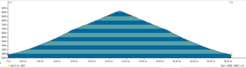
Onion Valley Trailhead Climb
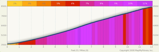
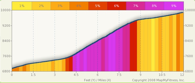
Starting at the Subway in Independence at a bright and early 1PM and cool 92 degrees, I headed up the road to Onion Valley. I knew the temperature at the end of the road (9,200 feet) would be much cooler - a great motivator to get up the hill as fast as possible. The road starts climbing immediately once you leave Highway 395, so there is little time to warm up. As the road travels up the alluvial fan to the base of the mountains, the grade gradually increases. I had expectations of only being able to ride at roughly 4 MPH all the way up, but luckily, my speed was usually between 5 and 6 MPH. The trouble going up was that there was a very strong head wind, and when the gusts came, my speed dropped nearly 1 MPH. That may not sound like much, but at these speeds, every MPH counts big time especially when you have 12 miles to climb. Once you reach the upper end of the alluvial fan near Grays Meadow Campground and Seven Pines, the road gets more exciting and the views improve as the road starts switchbacking up the mountainside.
At about 7,500 feet, I peeked back down the canyon I was climbing and saw a group of bicyclists heading up, about 1,000 below me. They looked like they were climbing fast, and I started having visions of Team Radio Shack flying up the mountain, with Lance coming alongside and racing me to the top. Yeah, whatever. Anyway, just below the top, my wife Cheryl (the SAG team leader, along with my son Kyle and dog Duke) drove up beside me and said that the other riders were the San Diego Descenders. The Descenders? No way! It was their website with their stories about their Monster Climb weekends that inspired me last year to do these crazy rides. Those guys are the real deal - no weenies in that group. Anyways, I beat their top riders to the top by about 10 or 15 minutes, but apparently they started about 1 hour after I did. I stopped a bunch of times to take photos...excuses, excuses.
It was good being able to meet the Descenders and talk about the rides they were doing this weekend. Coincidentally, they were into their first day of their 2010 Monster Climbs weekend, and their first two rides were nearly identical to mine. Onion Valley was their first climb, and on the following day, they would hit Pine Creek and Rock Creek. I told them I was planning on doing Rock Creek the following day too, and they invited me to join them to ride as a group. I didn’t feel up to doing both Pine Creek and Rock Creek in one day (I didn’t want to spend my wad so I couldn’t do Tioga), but I did want to ride Rock Creek with them. Anyway, the descent down Onion Valley was epic, to say the least. The headwind was now a tailwind, pushing us down the hill. Without the excessive sound of wind in my ears, I lost track of my speed. Just before the first switchback going down, I caught myself hitting 53 MPH! I hit this speed again multiple times on the way down - must be the terminal velocity for a bicyclist on a slope like this. It’s absolutely amazing how you can work so hard (though less than I thought) for just under 3 hours to get up there and come back down in only 24 minutes. But what a 24 minutes!
Rock Creek Road
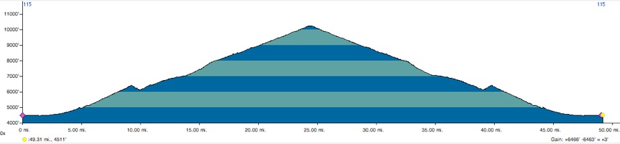
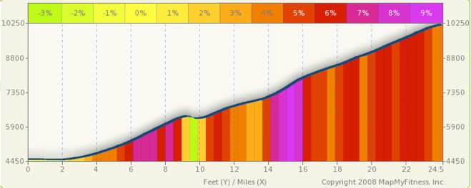
Okay, so with the steepest 10 miles in America checked off the list, the remaining two rides should be a little easier on the legs. Rock Creek is nearly divided into two equal portions (distance and climbing) - Lower and Upper Rock Creek roads. Lower Rock Creek Road starts just west of 395 outside the small community of Rovana. Starting around 10 AM and at 85 degrees, the first couple miles are gentle, traveling through the green Round Valley before climbing up Sherwin Grade and going through the little bedroom community of Paradise. The gentle, sweeping switchbacks of Sherwin Grade above Paradise are nicely graded, but still in the heat. Soon, the road descends to cross Rock Creek, but don’t worry, you only loose about 300 feet before climbing again. From here on out, you travel right alongside Rock Creek all the way to the end of the road. The sound and sights of the creek flowing with the rapidly melting snow made the ride mentally easier. Lower Rock Creek Road ends into 395, where we have to turn left and get off after about 1 mile at a small village called Toms Place. The first Descenders past me up along 395, but turned off to go to the Toms Place general store. Note that bicyclists can fill up there bottles or Camelbaks there using the hose on the right side of the general store. Toms Place is at about 7,000 feet and 14 miles into the ride.
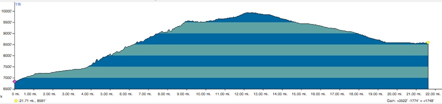
Toms Place marks the beginning of Upper Rock Creek Road, which is less exposed, cooler, and felt steeper than Lower Rock Creek Road. Soon, the air gets cooler as you enjoy the creek flow and aspen groves along the road. There are many campgrounds along the road, and early in the season, the road can be closed to cars at Rock Creek Lake or the pack station just beyond. Sure enough, with the late winter storms, the road was closed where it becomes a one-lane road at the pack station. But, that can’t stop a bike. There were a couple spots where we had to get off our bikes because of snow covering the road, but it made for a unique ride. It was kind of eerie arriving to the large, but empty, trailhead parking lot at 10,250 feet after 25 miles of climbing.
The fastest four Descenders past me just as we were riding by Rock Creek Lake, and I was able to rejoin them at the trailhead and waited as a couple more descenders made it to the top as well. The descent down Rock Creek was okay, bumpy in some spots, and with a ripple (like a speed bump with the top rounded part torn off to expose the hollow innards). However, once we reached Lower Rock Creek Road, the asphalt was smoother and was much more comfortable. The best part of the descent were the switchbacks along Sherwin Grade above Paradise. Riding solo, it still would have been okay, but if in a group spaced out just right so you can see the other riders ahead of you on the next switchback, the ride would be epic. With very exposed terrain, smooth road surfaces, and nice sweeping turns, the ride down was like an amusement park ride. It’s hard to describe - just ride it! Round Valley was nearly 97 degrees when we hit the bottom, so it was nice to jump in my wife’s SAG wagon.
Tioga Pass Road
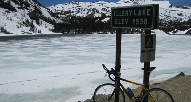
Now, with the steepest 10 miles in America and the highest paved road in California taken care of, the only remaining ride was to the highest paved pass in California - Tioga Pass. Starting where Tioga Pass Road (Highway 120) intersects 395, the climb up to the pass is really not that bad, except again, I had a very strong headwind. Lee Vining Creek canyon is one of the most spectacular backdrops of any road in the state, and is even more enjoyed while riding a bike. The ride became epic when I arrived at Ellery Lake. At this point, snow was nearly everywhere and all lakes above this point were frozen over. I never imagined I would be able to ride my bike in these kinds of conditions. We happened to time this ride just right, as Yosemite opened the road just the day before, and the scenery was absolutely incredible. It felt like I should have been on skis, not a road bike.
It happened to be National Park Day, so the park was not charging entrance fees, which was probably why there was so much traffic along Tioga Pass Road. After passing the entrance station, the descent was not very steep, and I had to pedal most of the way to stay above 30 MPH - a first for the weekend. Rapidly melting snow was causing water to flow all over the place, including on the road, and sometimes the only safe place to ride was right in the center of the crown along the double yellow lines. Once I reached Tuolumne, it felt nice to just cruise on flat terrain until the end of my ride: the Cathedral Lakes trailhead. I love spending time up in Tuolumne during the summer, but to see this area with so much snow made this ride unforgettable.
East Side Monster Climbs 2010 - Road
6/4/10
Last year, I fell in love with the Monster Climbs on the east side of the Sierras. Not only are they some of the longest and steepest rides in the nation, they are also in some of the most beautiful areas in the world. Plus, each climb is rewarded with an epic downhill - watch your speed!