SierraJourney - Cycling

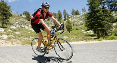
It seems that for each of the past several years, my wife and I have set “physically challenging” goals that seem unattainable. Last year, we were finally able to do something my wife had wanted to do for a long time and something I thought my body would never be able to handle - 26 days on the John Muir Trail, from Yosemite to Whitney. My friend Keith, being the animal that he is, not only did the JMT last year as well, but started his summer by riding the Climb to Kaiser (CTK)! Observing his training from the sidelines and listening to him talk about his experiences, I was convinced I wanted to do the ride too. But I felt I couldn’t do both in the same year.
I really had no idea what I was getting myself into. The longest ride I had ever done up to this point was probably a 70 mile ride from Hume Lake to the Little Baldy trailhead and back along General’s Highway in the Sequoia/Kings Canyon National Park area. All I remember about this ride is bonking somewhere around the 50 mile point and barely making it back to Hume (luckily it was downhill the last 10 miles). I never had the physical gift of endurance and never felt good on any ride past 30 miles, and at 50 miles I was usually burned out. So, you can say, I had a lot to learn and grow as a cyclist.
The Training
So, no sooner than a month or two after we got back from the JMT at the end of August 2008, you can say I started my “training”. I wanted to know if I even had a chance of finishing the the ride, so Keith and I rode from the town of Big Creek to Kaiser Pass. This ride included the infamous Big Creek Grade (the steepest in the CTK) and the highest altitude climb (Huntington Lake to Kaiser Pass). I figured, if I could do this without much training and with my 53/39 non-compact double crank, I had a chance. Well, I felt surprisingly good at the top of Kaiser after the ride and made the decision to train for the ride. My wife said she wouldn’t ride the CTK, but would support me during my training. She said she would train with me when she could, but, as it turned out, she pretty much rode with me on every training ride. She finally changed her mind to ride the CTK with me. So, as you read about the CTK below, my wife Cheryl was by my side pretty much every ride.
After this initial test ride, I am embarrassed to say that I really didn’t train until the Blossom Ride based out of Reedley in the beginning of March 2009. I had ridden short rides prior to the Blossom Ride, but little 15 to 30 mile rides don’t help with endurance if you never ride longer rides. To read about my struggles during the Blossom Ride (my first organized ride), please check out my story. Needless to say, the Blossom Ride was a wake-up call I desperately needed.
After this ride, I started planning out how I would train to the CTK. The first order of business was to ride every portion of the course to understand how to attack each climb, where your body can take a “rest”, and to estimate how fast I can/should ride throughout the course. You’re probably wondering about it, so I have a section below describing each of the major climbs.
My wife and I started with a nice “short” loop, starting at the Park and Ride parking lot at the intersection of Auberry Road and Highway 168 (just up the hill from Prather). This is a nice 30 mile ride, following 168 and Lodge Road to the town of Tollhouse, climbing up the wonderful Tollhouse Grade to the top of the Four Lanes along 168, then crossing 168 and following Auberry Road along the top of the ridge above the Four Lanes back down to the town of Auberry, and then back to the parking lot.
Next, we wanted to experience the entire lower “loop” of the CTK before the weather got too hot (it never got hot, though, before the CTK). Starting from our northeast Fresno home, we rode through Clovis and down to Ashlan and Academy Avenues to the beginning of Watts Valley Road. After riding along through some beautiful terrain (spring-time), we made our way up the Wildcat Grade. I don’t know why people always talk about Wildcat being so bad. It’s the shortest of the climbs and there is only one really steep stretch that only lasts a couple of minutes (if that). Obviously these people have never climbed Big Creek before. Anyway, then we worked our way up and over the Burrough Grade and through Burrough Valley. This is a beautiful area in the spring when the hills are bright green. Burrough is a nice easy climb, probably the fastest major climb of the CTK. Then, it was down to Tollhouse, up Tollhouse Grade and on to Shaver Lake where we turned around. Once back at the time top of the Four Lanes, turn right onto Auberry Road and follow it back to 168. The course then takes you back to Prather and back along Auberry Road to Copper Avenue.
Now on to our favorite training ride - the Upper Loop. I’m not sure if this ride actually has a name, but my wife and I call it that and it’s name is fitting. Basically, it’s the upper “loop” of the CTK ride. The first time we rode this, we started in Shaver at So. Cal. Edison’s public beach along 168, followed 168 to the Shaver Lake Marina where we turned left onto Big Creek Road, descended (and ascended) to the small power plant town of Big Creek, up the Big Creek Grade, along Huntington Lake to Kaiser Pass Road, up Kaiser Pass Road to the pass and back to 168, then up Tamarack Ridge and back down to Shaver. After riding this loop several times, we realized we were not giving our legs enough warm-up time before making the first set of ascents. So, we started training by parking the car near the Huntington Lake dam and starting the loop from there. This proved to be much better, with over 5 miles of warm-up time before climbing up the Kaiser Pass Grade. This ride is still something my wife and I enjoy doing even after the CTK. It’s combination of great scenery, cooler weather, and awesome climbs make for a very satisfying Saturday afternoon ride.
Nutrition
I’m going to start with a disclaimer: I am not an expert in nutrition. I am still learning a bunch about endurance nutrition, as it is much different than nutrition suitable for events up to 3 hours. Having said this, I’m not going to write much on this topic except about what I have learned during my training for the CTK. At first, I was simply using Cliff Bars and Cliff Shots (gels) during my long rides. After reading some information on various websites (including some article written by Hammer Products for Planet Ultra), I decided to try Hammer’s Perpetuem energy drink/shake. This drink is intended to be used during endurance events (activities longer than 3 hours). Hammer recommends mixing 2 scoops of this powder with water for ever hour of exercise. After experimenting, I found that I can mix 8 scoops with water in a typical larger bicycle water bottle. This would give me 4 hours worth of this energy drink, and I would need to take a sip or two every 20 minutes or so. You’re probably wondering what is in this drink and if it works. Basically, this drink includes everything that you need to keep your body performing during endurance events. It gives you calories, carbs (the good stuff from maltodextrin), fat, potassium, and a bunch of minerals. Two scoops of power give you 250 calories, so, my 4-hour drink will give me 1,000 calories - quite impressive. At the end of the first ride when I used this drink, I was not hungry - incredible! I feel as if this stuff helps, if not prevents, myself from bonking on long rides. However, on the CTK, my stomach started feeling a little upset by the time I reached Huntington Lake. I may have consumed too much of this stuff without eating any actual food. I ate a small sandwich along with some Tums, and I felt better again. There was probably just too much of this miracle liquid in my stomach sloshing around. So, give this drink a try. Oh, yeah, I forgot - it tastes like a real mild orange smoothy.
The Climbs
Below is a summary of the major climbs of the CTK.
Wildcat Grade
This is the first “major” climb of the CTK, starting at an elevation of approximately 975 feet at the “Corral” junction and then approximately 3.5 miles to the top at an elevation just under 2,000 feet. There is really only one steep portion, about 0.5 miles from the top near the driveway with garbage cans, where you might need to stand up. Other than that, it’s a nice short climb. To put things in perspective, the Big Creek Grade is about the same length but is double the elevation gain. There is a rest stop at the top of Wildcat during the CTK ride, but it’s more of a social stop than a necessity. You have a nice decent immediately after this climb to relax and take a break.
Burrough Grade
The Burrough Grade just before arriving in Burrough Valley is a very pleasant, steady climb. It’s likely the fastest climb on the CTK (I don’t think it’s that difficult to sustain 8 to 10 MPH during the entire ascent). During the training season prior to the CTK, the hillsides in this region are deep green with patches of bright yellow flowers scattered throughout - very beautiful. The climb starts at the intersection of Watts Valley Road and Maxson Road (where we turn left) at an elevation of approximately 1,360 feet. The climb is approximately 2.5 miles long and climbs to 1,990 feet before the short descent into Burrough Valley.
Tollhouse Grade
Ah, the lovely Tollhouse climb - the one that gets you up into the cooler mountain environment. This one is my wife’s favorite climb (other than Kaiser Pass) for good reason. Except for the last 0.7 mile or so, the climb is at a nice steady grade and offers great views. The last 0.7 mile or so (starting at the Forest Service Mountain Rest Station) is totally gnarly and ruins your nice pace you had for the last 6 or so miles. Starting at the small town of Tollhouse at about 1,900 feet, this climb lasts 6.5 miles and ends at Highway 168 at approximately 4,500 feet. The CTK has a water aid station at the Mountain Rest Station, but I’d recommend skipping this if you can. If you do decide to stop, you have to immediately start climbing up a hill that is probably 15% or so - not so good for your cooled-down legs.
Shaver Climb
The next major climb is that from the top of Tollhouse Road to Shaver Lake. It’s easy to discount this stretch of the ride as a minor climb, but you need to be mentally prepared for this ascent. This climb lasts about 3.3 miles and climbs to approximately 5,500 feet (1,000 feet of total ascent). These values are for the main part of the climb that ends about 1.4 miles before Ockenden Ranch. The difficult part of this climb is mental - dealing with all the traffic whizzing by when you rarely has a shoulder to ride in. After you reach what I call the top of the climb, it’s mainly rollers until you reach the Shaver Lake dam and marina.
Big Creek - The Real Deal
After climbing this grade, you will compare all climbs to this - and rarely will anything else be close to its shear awesomeness. Starting at the small power plant town of Big Creek at an elevation of about 4,950 feet, you climb to the Huntington Lake dam at an elevation of 6,975 feet in only 3.8 miles (10% grade average). Some spots approach 15 to 20%, and make you question your bike’s traction and if you can keep your front wheel on the ground. In my opinion, the trick to this climb is to not stop, which is much easier said than done. During the steepest parts, my mind is constantly telling me “Oh, come on, take a break. You’ll feel so much better.” Resist that temptation! Just keep pushing, even if you have to slow down to below 3 miles per hour. My best time (as of August 7, 2009) from the BIg Creek general store to the dam was 45 minutes, and somehow, I never dropped below 4 MPH (at least I don’t think I did). Keep in mind that once you get to the dam, you’ll have 6 miles of mostly flat with some rollers as you approach Kaiser Pass Road. This is a good opportunity to give your legs a break before the next climb.
Kaiser Pass
The climb to the highest point on the CTK awaits you at the top of this climb. Starting at the inlet to Huntington Lake at 6,970 feet, the Kaiser Pass Road continues 7.2 miles to Kaiser Pass at 9,184 feet. After 5.6 miles at an elevation of about 8,360, the road makes a hard right and transitions from a nice two lane “highway” to a poorly paved single lane road that is significantly steeper than the first section. I believe it is as this location that the attempt to make a trans-Sierra highway, that would involve the construction of tunnels, ended. There was a 100-foot long portion of the upper section of road, just below the top, that was unpaved. But, as of July 31, 2009 (when I drove up there), this dirt section has been paved! Kind of a bummer - it added character to the CTK ride. Anyway, Kaiser Pass is high and I usually start feeling the effects of altitude at around 9,000 feet. It’s a shame that there is really no view at Kaiser Pass.
Tamarack Pass
The final “major climb”, this climb actually consists of 3 to 4 smaller climbs in sequence. The entire climb is nicely graded, with the steepest part being the last 2 miles or so (or maybe it just feels that way because you’ve been climbing for a while). The actual Tamarack Pass is at only about 7,600 feet (remember that you started at about 7,000 feet at Huntington Lake). Just prepare your mind that you will climb and fall several times before you finally crest the pass and enjoy the wonderful descent down to Shaver Lake. It’s almost all downhill from here. Compared to what you had already climbed up to this point, the climbing is basically done.
Climb to Kaiser 2009 - Road
6/27/09
The Fresno Cycling Club organizes an annual ride called the Climb to Kaiser. Bicycling Magazine rated it as one of the nation’s 10 most difficult rides. Combine 155 miles, 14,500 feet of climbing, and nice hot Fresno June weather, and you’ve got a classic!